Study accurately dates coral loss at Great Barrier Reef
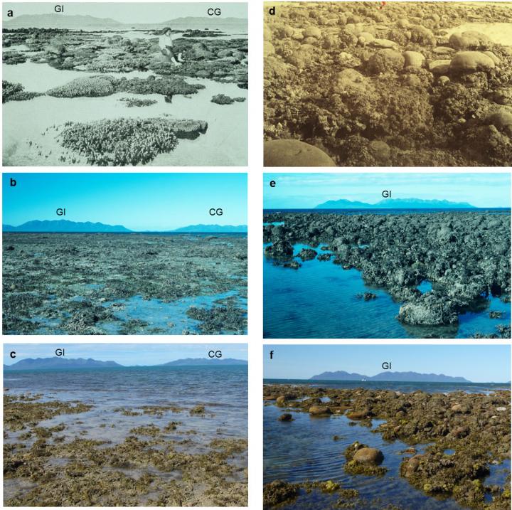
Historical and modern photographs of Stone Island taken in a) 1915 (photographer unknown); b) 1994 (photographer A. Elliot © Commonwealth of Australia GBRMPA); c) 2012 (photographer H. Markham); and Bramston Reef taken in d) c.1890 (W. Saville-Kent); e) 1994 (photographer A. Elliot © Commonwealth of Australia GBRMPA); f) 2012 (photographer T. Clark). Landscape features in the background of the images helped to locate the same sites: Gloucester Island (GI) and Cape Gloucester (CG). Credit Source: Clark et al. 2016. The timing of significant Great Barrier Reef coral loss captured by a series of historical photos has been accurately determined for the first time by a University of Queensland)-led study.
Environment
-
Arctic gives clues on worst mass extinction of life
-

Specialized life forms abound at Arctic methane seeps
-
Marine carbon sinking rates confirm importance of polar oceans
-
Ocean warming and acidification impact on calcareous phytoplankton
-
Watching a forest breathe
-
Microplastic particles threaten fish larvae
-
Honeybees pick up 'astonishing' number of pesticides via non-crop plants
-
West Coast scientists sound alarm for changing ocean chemistry
-
Herpes outbreak, other marine viruses linked to coral bleaching event
-
Tough times for the tree of life on coral reefs
-
Rapid plankton growth in ocean seen as sign of carbon dioxide loading
-
Lab experiments question popular measure of ancient ocean temperatures
-
Bering Sea hotspot for corals and sponges
-
Great Barrier Reef marine reserves combat coral disease
-
Brazilian beef industry moves to reduce its destruction of rain forests
